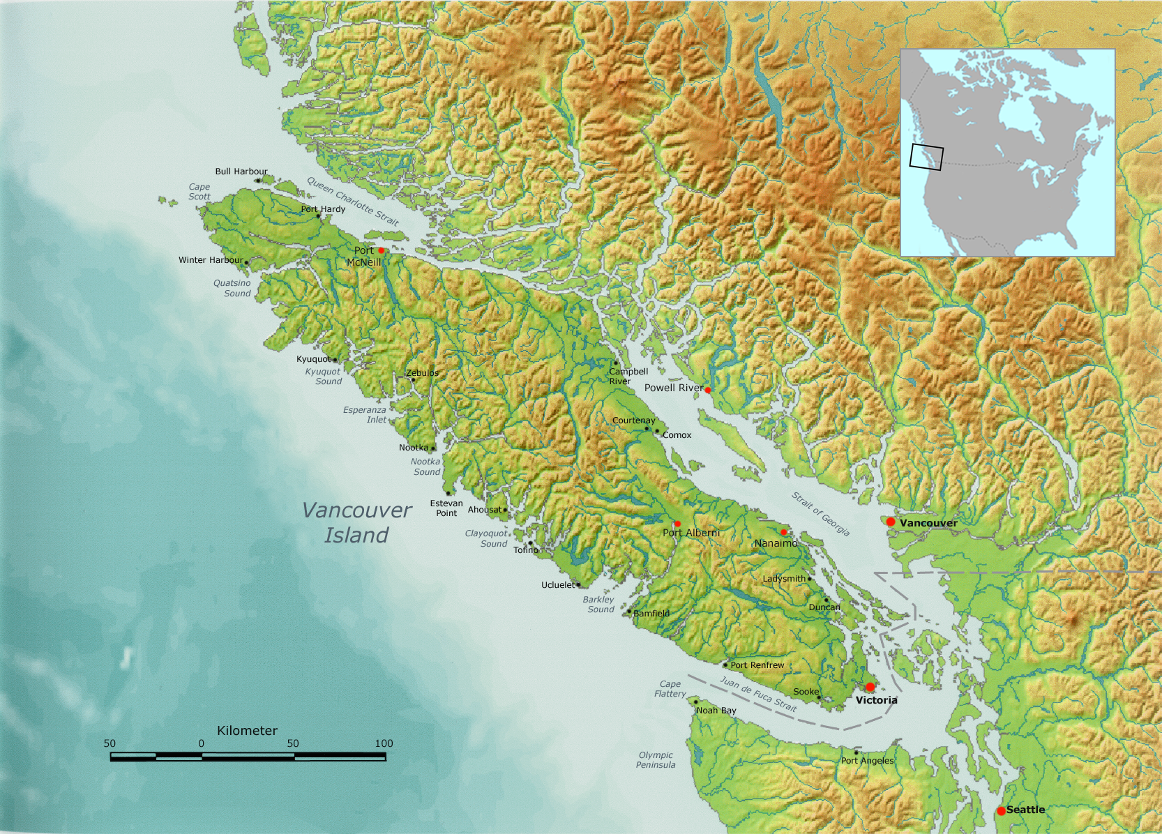
Queen Charlotte Strait — is a strait between Vancouver Island and the mainland of British Columbia, Canada. It connects Queen Charlotte Sound with Johnstone Strait, Discovery Passage and then to the Strait of Georgia and Puget Sound. It forms part of the Inside Passage… … Wikipedia
Queen Charlotte Strait — Sp Karalienės Karolinos sąsiauris Ap Queen Charlotte Strait L tarp Vankuverio s. ir žemyno, Kanada … Pasaulio vietovardžiai. Internetinė duomenų bazė
Queen Charlotte Sound (Canada) — There is also a Queen Charlotte Sound, New Zealand. Queen Charlotte Sound is a sound of the Pacific Ocean in British Columbia, Canada, between Vancouver Island in the south and the Queen Charlotte Islands in the north. It merges with Hecate… … Wikipedia
Queen Charlotte Sound — Broad, deep inlet of the Pacific Ocean indenting western British Columbia, Canada. Bounded on the north by the Queen Charlotte Islands and on the south by Vancouver Island, the sound feeds into a series of straits that once were the paths… … Universalium
Queen Charlotte Basin — lies mostly beneath the continental shelf offshore, between the Queen Charlotte Islands, Vancouver Island, and the British Columbia mainland. The term Queen Charlotte Basin normally refers to the Tertiary rocks, but these are underlain by what… … Wikipedia
Queen Charlotte Sound, New Zealand — Queen Charlotte Sound is the easternmost of the main sounds of the Marlborough Sounds, in New Zealand s South Island. It is, like the other sounds, a drowned valley, and like the majority of its neighbours it runs southwest to northeast before… … Wikipedia
Queen Charlotte Islands — Infobox Islands name = Queen Charlotte Islands image caption = image size = locator map custom = no native name = Haida Gwaii native name link = Haida language nickname = location = Pacific Ocean coordinates =… … Wikipedia
Queen Charlotte Islands — a group of islands in British Columbia off the W coast of Canada. 2222; 3970 sq. mi. (10,280 sq. km). * * * Group of about 150 islands (pop., 2001: 4,935) off western British Columbia, Canada. They have an area of 3,705 sq mi (9,596 sq km). The… … Universalium
Graham Island (Queen Charlotte Islands) — Vorlage:Infobox Insel/Wartung/Höhe fehlt Graham Island Karte der Queen Charlotte Islands, Graham Island ist die nördliche Hauptinsel Gewässer … Deutsch Wikipedia
Strait of Hecate — Karte (genordet) die Hecate Strait ist südöstlich zu finden Die Hecate Strait oder Strait of Hecate ist ein schiffbares Gewässer in Westkanada. Es trennt die Queen Charlotte Islands (Haida Gwaii) vom Festland British Columbias und hat eine Länge… … Deutsch Wikipedia
 Lage nordöstlich von Vancouver Island