- Pozzorubio
-
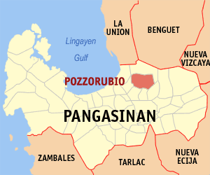
Municipality of Pozzorubio Lage von Pozzorubio in der Provinz Pangasinán 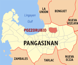
Basisdaten Bezirk: Ilocos-Region Provinz: Pangasinán Barangays: 34 Distrikt: 5. Distrikt von Pangasinán PSGC: 015530000 Einkommensklasse: 2. Einkommensklasse Haushalte: 11.288 Zensus 1. Mai 2000Einwohnerzahl: 63.689 Zensus 1. August 2007Bevölkerungsdichte: 710,4 Einwohner je km² Fläche: 89,65 km² Koordinaten: 16° 7′ N, 120° 33′ O16.116666666667120.55Koordinaten: 16° 7′ N, 120° 33′ O Postleitzahl: 2435 Vorwahl: +63 75 Geographische Lage auf den Philippinen 

Pozzorubio Pozzorubio (das ehemalige Claris oder Pozzorrubio) ist eine Stadtgemeinde in der philippinischen Provinz Pangasinán. In dem 89,65 km² großen Gebiet wohnten im Jahre 2000 56.340 Menschen, wodurch sich eine Bevölkerungsdichte von 628,44 Einwohnern pro km² ergibt. Das meist flache Gelände grenzt an die philippinischen Kordilleren.
Pozzorubio ist in die folgenden 34 Baranggays aufgeteilt:
- Alipangpang
- Amagbagan
- Balacag
- Banding
- Bantugan
- Batakil
- Bobonan
- Buneg
- Cablong
- Casanfernandoan
- Castaño
- Dilan
- Don Benito
- Haway
- Imbalbalatong
- Inoman
- Laoac
- Maambal
- Malasin
- Malokiat
- Manaol
- Nama
- Nantangalan
- Palacpalac
- Palguyod
- Poblacion I
- Poblacion II
- Poblacion III
- Poblacion IV
- Rosario
- Sugcong
- Talogtog
- Tulnac
- Villegas
Anmerkung: Población (spanisch für Population) bezeichnet auf den Philippinen oft mehrere im Zentrum einer Stadtgemeinde liegende Barangays.
Städte und Stadtgemeinden in der Provinz PangasinánStädte: Alaminos | Dagupan | San Carlos City | Urdaneta
Stadtgemeinden: Agno | Aguilar | Alcala | Anda | Asingan | Balungao | Bani | Basista | Bautista | Bayambang | Binalonan | Binmaley | Bolinao | Bugallon | Burgos | Calasiao | Dasol | Infanta | Labrador | Laoac | Lingayén | Mabini | Malasiqui | Manaoag | Mangaldan | Mangatarem | Mapandan | Natividad | Pozzorubio | Rosales | San Fabian | San Jacinto | San Manuel | San Nicolas | San Quintin | Santa Barbara | Santa Maria | Santo Tomas | Sison | Sual | Tayug | Umingan | Urbiztondo | Villasis
Wikimedia Foundation.
Schlagen Sie auch in anderen Wörterbüchern nach:
Legislative districts of Pangasinan — Philippines This article is part of the series: Politics and government of the Philippines … Wikipedia
Anda (Pangasinan) — Municipality of Anda Lage von Anda in der Provinz Pangasinán Basisdaten Bezirk: Ilocos Region … Deutsch Wikipedia
Dagupan — City Lage von Dagupan in der Provinz Pangasinán Basisdaten Bezirk: Ilocos Region … Deutsch Wikipedia
Lingayen — Municipality of Lingayén Lage von Lingayen in der Provinz Pangasinán Basisdaten Bezirk: Ilocos Region … Deutsch Wikipedia
PH-PAN — Lage der Provinz Pangasinán ist eine philippinische Provinz in dem Bezirk Ilocos auf der Hauptinsel Luzón. Die Hauptstadt der Provinz ist Lingayen, welche am gleichnamigen Golf von Lingayen sowie an der Mündung des Flusses Agno liegt. Pangasinán… … Deutsch Wikipedia
Pangasinan — Lage der Provinz Pangasinán ist eine philippinische Provinz in dem Bezirk Ilocos auf der Hauptinsel Luzón. Die Hauptstadt der Provinz ist Lingayen, welche am gleichnamigen Golf von Lingayen sowie an der Mündung des Flusses Agno liegt. Pangasinán… … Deutsch Wikipedia
San Carlos (Pangasinan) — San Carlos City Lage von San Carlos City in der Provinz Pangasinán Basisdaten Bezirk: Ilocos Region … Deutsch Wikipedia
Pozorrubio, Pangasinan — Infobox Philippine municipality infoboxtitle = Municipality of Pozorrubio, Pangasinan sealfile = Pozorrubio Pangasinan.png region = Ilocos Region (Region I) province = Pangasinan pop2000 = 58,252 barangays = 34 districts = 5th District,… … Wikipedia
Tuba, Benguet — Infobox Philippine municipality infoboxtitle = Municipality of Tuba sealfile = Ph seal benguet tuba.png locatormapfile = Ph locator benguet tuba.png caption = Map of Benguet showing the location of Tuba. region = Cordillera Administrative Region… … Wikipedia
List of cities and municipalities in the Philippines — This is a list of cities and municipalities in the Philippines arranged by province and in alphabetical order. As of 2006, there are 118 cities and 1509 municipalities.As of September 4, 2007, there are 136 cities, 1,495 municipalities, 81… … Wikipedia
Pozzorubio

18+
© Academic, 2000-2024
- Kontaktieren Sie uns: Unterstützung, Werbung
Wörterbücher Export, schritte mit PHP, Joomla, Drupal, WordPress, MODx.