- Piatt County
-
 Piatt County Courthouse in Monticello
Verwaltung US-Bundesstaat: Illinois Verwaltungssitz: Monticello Adresse des
Verwaltungssitzes:County Courthouse
101 West Washington Street
Monticello, IL 61856-1672Gründung: 20. Januar 1841 Gebildet aus: DeWitt County
Macon CountyVorwahl: 001 217 Demographie Einwohner: 16.365 (2000) Bevölkerungsdichte: 14,4 Einwohner/km² Geographie Fläche gesamt: 1.140 km² Wasserfläche: 1 km² Karte 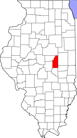
Website: www.piattcounty.org Das Piatt County[1] ist ein County in der Mitte des US-Bundesstaates Illinois. Im Jahr 2000 hatte das County 16.365 Einwohner und eine Bevölkerungsdichte von 14 Einwohnern je Quadratkilometer. Der Verwaltungssitz (County Seat) ist Monticello.
Inhaltsverzeichnis
Geografie
Das County liegt im Osten von Illinois, etwa 70 Kilometer vom geographischen Mittelpunkt des Bundesstaates und hat eine Fläche von 1140 Quadratkilometern, wovon 1 Quadratkilometer Wasserfläche ist. Es grenzt im Uhrzeigersinn an folgende Countys: Champaign County, Douglas County, Moultrie County, Macon County, DeWitt County und McLean County.
Geschichte
Piatt County wurde am 20. Januar 1841 aus dem südöstlichen Teil des DeWitt County und dem nordöstlichen Teil des Macon County gebildet. Benannt wurde es nach Benjamin Piatt, einem Pionier, Juristen und Generalstaatsanwalt des Territoriums Illinois von 1810 bis 1813.
Demografische Daten
Historische Einwohnerzahlen Census Einwohner ± in % 1850 1606 — 1860 6127 300 % 1870 10.953 80 % 1880 15.583 40 % 1890 17.026 9 % 1900 17.706 4 % 1910 16.376 -8 % 1920 15.714 -4 % 1930 15.588 -0,8 % 1940 14.659 -6 % 1950 13.970 -5 % 1960 14.960 7 % 1970 15.509 4 % 1980 16.581 7 % 1990 15.548 -6 % 2000 16.365 5 % Vor 1900[2] 1900–1990[3]
 Karte des Piatt Countys
Nach der Volkszählung im Jahr 2000 lebten im Piatt County 16.365 Menschen. Davon wohnten 192 Personen in Sammelunterkünften, die anderen Einwohner lebten in 6.475 Haushalten und 4.726 Familien. Die Bevölkerungsdichte betrug 14 Einwohner pro Quadratkilometer. Ethnisch betrachtet setzte sich die Bevölkerung zusammen aus 98,83 Prozent Weißen, 0,24 Prozent Afroamerikanern, 0,08 Prozent amerikanischen Ureinwohnern, 0,13 Prozent Asiaten, 0,02 Prozent Bewohnern aus dem pazifischen Inselraum und 0,14 Prozent aus anderen ethnischen Gruppen; 0,57 Prozent stammten von zwei oder mehr Ethnien ab. 0,62 Prozent der Bevölkerung waren spanischer oder lateinamerikanischer Abstammung.
Von den 6.475 Haushalten hatten 32,6 Prozent Kinder und Jugendliche unter 18 Jahre, die bei ihnen lebten. 63,3 Prozent waren verheiratete, zusammenlebende Paare, 6,8 Prozent waren allein erziehende Mütter, 27,0 Prozent waren keine Familien, 23,7 Prozent waren Singlehaushalte und in 11,8 Prozent lebten Menschen im Alter von 65 Jahren oder darüber. Die Durchschnittshaushaltsgröße betrug 2,50 und die durchschnittliche Familiengröße lag bei 2,96 Personen.
Auf das gesamte County bezogen setzte sich die Bevölkerung zusammen aus 25,1 Prozent Einwohnern unter 18 Jahren, 6,8 Prozent zwischen 18 und 24 Jahren, 27,6 Prozent zwischen 25 und 44 Jahren, 25,0 Prozent zwischen 45 und 64 Jahren und 15,5 Prozent waren über 65 Jahre alt. Das Durchschnittsalter betrug 40 Jahre. Auf 100 weibliche Personen kamen 95,4 männliche Personen. Auf 100 Frauen im Alter von 18 Jahren oder darüber kamen statistisch 91,9 Männer.
Das jährliche Durchschnittseinkommen eines Haushalts betrug 45.752 US-Dollar, das Durchschnittseinkommen der Familien betrug 52.218 USD. Männer hatten ein Durchschnittseinkommen von 36.762 USD, Frauen 23.606 USD. Das Pro-Kopf-Einkommen betrug 21.075 USD. 3,6 Prozent der Bevölkerung und 5,0 Prozent der Familien lebten unterhalb der Armutsgrenze. [4]
Städte und Gemeinden
- Atwood1
- Bement
- Cerro Gordo
- Cisco
- De Land
- Hammond
- Mansfield
- Monticello
1 - teilweise im Douglas County
Einzelnachweise
- ↑ GNIS-ID: 424275. Abgerufen am 22. Februar 2011 (englisch).
- ↑ U.S. Census Bureau - Census of Population and Housing. Abgerufen am 15. März 2011
- ↑ Auszug aus Census.gov. Abgerufen am 15. Februar 2011
- ↑ Piatt County, Illinois, Datenblatt mit den Ergebnissen der Volkszählung im Jahre 2000 bei factfinder.census.gov.

Liste der Countys in Illinois
Adams | Alexander | Bond | Boone | Brown | Bureau | Calhoun | Carroll | Cass | Champaign | Christian | Clark | Clay | Clinton | Coles | Cook | Crawford | Cumberland | DeKalb | DeWitt | Douglas | DuPage | Edgar | Edwards | Effingham | Fayette | Ford | Franklin | Fulton | Gallatin | Greene | Grundy | Hamilton | Hancock | Hardin | Henderson | Henry | Iroquois | Jackson | Jasper | Jefferson | Jersey | Jo Daviess | Johnson | Kane | Kankakee | Kendall | Knox | LaSalle County | Lake | Lawrence | Lee | Livingston | Logan | Macon | Macoupin | Madison | Marion | Marshall | Mason | Massac | McDonough | McHenry | McLean | Menard | Mercer | Monroe | Montgomery | Morgan | Moultrie | Ogle | Peoria | Perry | Piatt | Pike | Pope | Pulaski | Putnam | Randolph | Richland | Rock Island | Saline | Sangamon | Schuyler | Scott | Shelby | St. Clair | Stark | Stephenson | Tazewell | Union | Vermilion | Wabash | Warren | Washington | Wayne | White | Whiteside | Will | Williamson | Winnebago | Woodford
Wikimedia Foundation.
Schlagen Sie auch in anderen Wörterbüchern nach:
Piatt County — Admin ASC 2 Code Orig. name Piatt County Country and Admin Code US.IL.147 US … World countries Adminstrative division ASC I-II
Piatt County, Illinois — Infobox U.S. County county = Piatt County state = Illinois seallink = map size = 150 founded = 1841 seat = Monticello largest city = Monticello area total sq mi = 440 area total km2 = 1140 area land sq mi = 440 area land km2 = 1140 area water sq… … Wikipedia
Monticello Township, Piatt County, Illinois — Monticello Township Township Location in Piatt County … Wikipedia
Cerro Gordo Township, Piatt County, Illinois — Cerro Gordo Township Township Location in Piatt County … Wikipedia
Bement Township, Piatt County, Illinois — Infobox Settlement official name = Bement Township settlement type = Township nickname = motto = imagesize = image caption = image imagesize = image caption = image mapsize = map caption = Location in Piatt County mapsize1 = map caption1 =… … Wikipedia
Blue Ridge Township, Piatt County, Illinois — Infobox Settlement official name = Blue Ridge Township settlement type = Township nickname = motto = imagesize = image caption = image imagesize = image caption = image mapsize = map caption = Location in Piatt County mapsize1 = map caption1 =… … Wikipedia
Goose Creek Township, Piatt County, Illinois — Infobox Settlement official name = Goose Creek Township settlement type = Township nickname = motto = imagesize = image caption = image imagesize = image caption = image mapsize = map caption = Location in Piatt County mapsize1 = map caption1 =… … Wikipedia
Unity Township, Piatt County, Illinois — Infobox Settlement official name = Unity Township settlement type = Township nickname = motto = imagesize = image caption = image imagesize = image caption = image mapsize = map caption = Location in Piatt County mapsize1 = map caption1 =… … Wikipedia
Willow Branch Township, Piatt County, Illinois — Infobox Settlement official name = Willow Branch Township settlement type = Township nickname = motto = imagesize = image caption = image imagesize = image caption = image mapsize = map caption = Location in Piatt County mapsize1 = map caption1 … Wikipedia
Sangamon Township, Piatt County, Illinois — Infobox Settlement official name = Sangamon Township settlement type = Township nickname = motto = imagesize = image caption = image imagesize = image caption = image mapsize = map caption = Location in Piatt County mapsize1 = map caption1 =… … Wikipedia
Piatt County


18+
© Academic, 2000-2024
- Kontaktieren Sie uns: Unterstützung, Werbung
Wörterbücher Export, schritte mit PHP, Joomla, Drupal, WordPress, MODx.