- Atiu
-
Atiu Satellitenbild von Atiu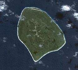
Gewässer Pazifischer Ozean Inselgruppe Cookinseln Geographische Lage 19° 59′ 0″ S, 158° 7′ 0″ W-19.983333333333-158.1166666666770Koordinaten: 19° 59′ 0″ S, 158° 7′ 0″ W 

Länge 7,2 km Breite 4,8 km Fläche 26,9 km² Höchste Erhebung 70 m Einwohner 570 (2006)
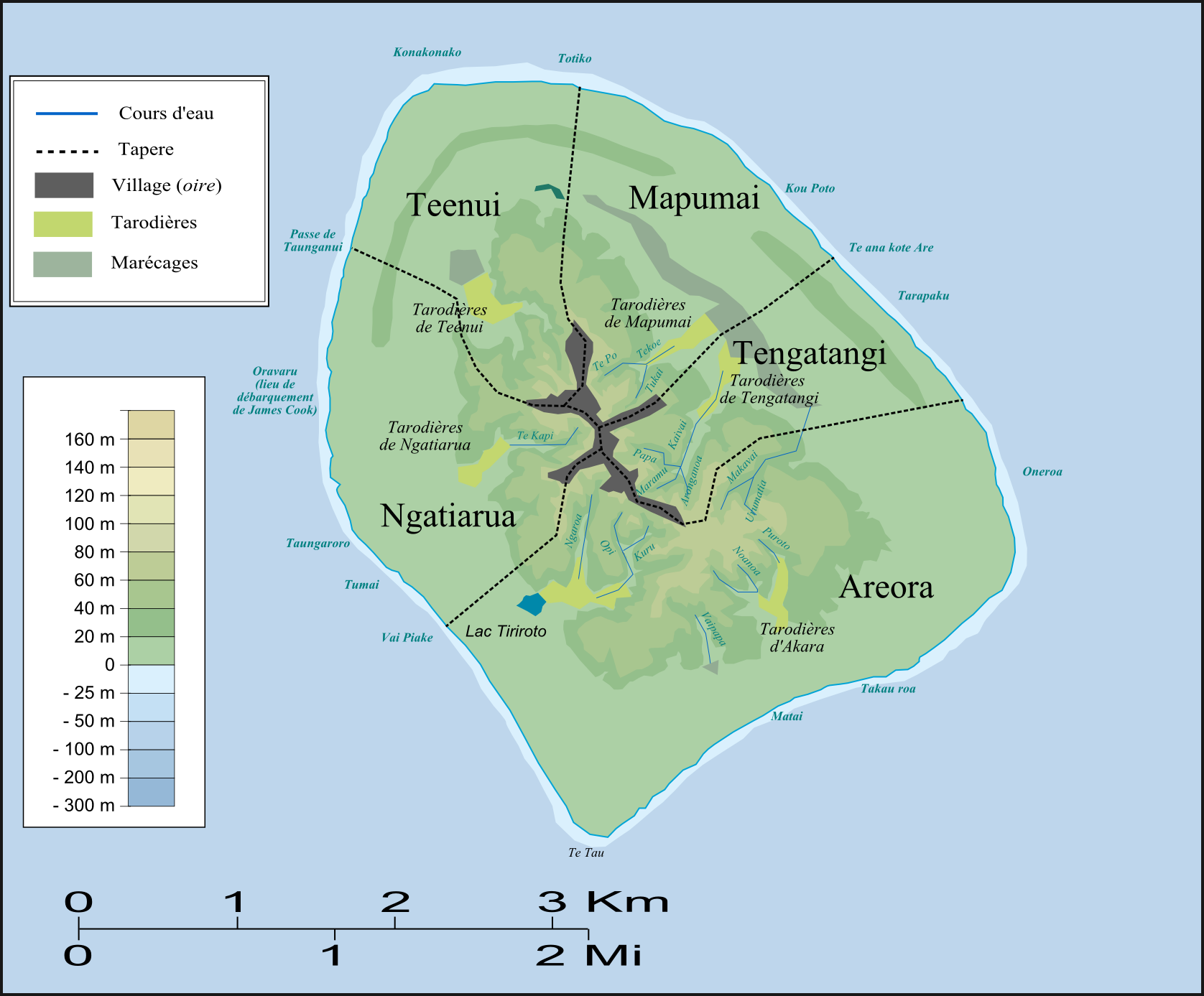
21 Einw./km²Hauptort Mapumai Karte von Atiu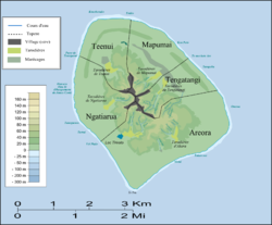
Atiu (auch Enuamanu genannt) ist eine zu den polynesischen Cookinseln gehörende 27 km² große Insel. Sie gehört zur südlichen Inselgruppe der Cookinseln und liegt 187 km nordöstlich der Hauptinsel Rarotonga. Auf Atiu leben knapp 570 Einwohner (Zensus 2006)[1] in fünf Dörfern. Die Einwohnerzahl sinkt aufgrund von Auswanderung nach Neuseeland und Australien rapide; zum Zensus 2001 hatte Atiu noch eine Bevölkerung von 623.
Atiu ist etwa 11 Millionen Jahre alt und vulkanischen Ursprungs. Sie hebt sich, im Gegensatz zu den meisten anderen Vulkaninseln des Südpazifik, immer noch etwa 0,2 mm pro Jahr vom Meeresboden empor. Sie ist aus einem Hot-Spot in der Erdkruste hervorgegangen, aus dem ein unterseeischer Vulkan entstand, der allerdings erlosch bevor er die Meeresoberfläche erreichen konnte. Infolge der langsamen tektonischen Bewegung des Meeresbodens wurde dieser im Laufe eines Zeitraumes von 8 Millionen Jahren mitsamt dem erloschenen Vulkan (dem heutigen Atiu) angehoben, so dass das unter der Oberfläche gelegene Korallenriff schließlich aus dem Wasser auftauchte. Die Insel besteht fast ausschließlich aus Korallengestein mit nur wenigen Taschen fruchtbaren Bodens, auf dem Landwirtschaft möglich ist.
Siehe auch
Weblinks
 Commons: Atiu – Sammlung von Bildern, Videos und Audiodateien
Einzelnachweise
- ↑ Census 2006 (englisch; PDF)
Schlagen Sie auch in anderen Wörterbüchern nach:
Atiu — Atiu, also known as Enuamanu (meaning land of the birds ), is an island lying at 187 km to the northeast of Rarotonga, in the Southern Islands group of the Cook Islands Archipelago.GeographyAtiu is a raised volcanic island surrounded by a reef… … Wikipedia
atiu — interj., atiū, atiùi tule (vilką vejant, leliojant): Ji mojuodavo, šmetakuodavo vytine ir visa gerkle šaukdavo: atiu! atiu! A.Vien. Atiū, vilką, atiū! rš. Atiùi vilką, atiùi vilką! Dkš. Kai pamatysi vilką, tai rėk „atiùi, atiùi! Nmn … Dictionary of the Lithuanian Language
Atiu — Enuamanu Carte d Atiu. Géographie Pays … Wikipédia en Français
Atiu — Saltar a navegación, búsqueda Atiu / Enuamanu Localización País Estado asociado con Nueva Zelanda … Wikipedia Español
Atiu — (Wa tiu), Insel im Cooks Archipel, 4 QM. groß, viel Holz, Kokosbäume u. 2000 Ew … Pierer's Universal-Lexikon
Atiu — ▪ island, Cook Islands, Pacific Ocean one of the southern Cook Islands, a self governing state in free association with New Zealand in the South Pacific Ocean. A raised coral atoll, Atiu has a circumference of roughly 20 miles (30 km); a… … Universalium
Atiu Guesthouse — (Atiu,острова Кука) Категория отеля: Адрес: P.O.Box 13, N/A Atiu, острова Кука … Каталог отелей
Atiu Villas — (Atiu,острова Кука) Категория отеля: 3 звездочный отель Адрес: Box 7, 000 Atiu, острова … Каталог отелей
Atiu Swiftlet — Conservation status Vulnerable (IUCN 3.1) Scientific classification Kingdom … Wikipedia
Atiu (circonscription) — Circonscriptions électorales des îles Cook Atiu Elections 2006 X 2004 X … Wikipédia en Français
Atiu


18+
© Academic, 2000-2024
- Kontaktieren Sie uns: Unterstützung, Werbung
Wörterbücher Export, schritte mit PHP, Joomla, Drupal, WordPress, MODx.