Parkes Shire

Parkes Shire
Shire of Parkes
Australia-Map-NSW-LGA-Parkes.png
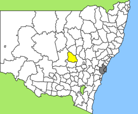
Lage des Parkes Shire in New South Wales
Gliederung
Staat: Australien Australien
Bundesstaat: Flag of New South Wales.svg New South Wales
Verwaltungssitz: Parkes
Daten und Zahlen
Fläche: 5.958 km²
Einwohner: 14.281 (2006) [1]
Bevölkerungsdichte: 2,4 Einwohner je km²
-32.933333333333148.01666666667

Parkes Shire ist ein lokales Verwaltungsgebiet (LGA) im australischen Bundesstaat New South Wales. Das Gebiet ist 5.958 km² groß und hat etwa 15.000 Einwohner.

Parkes liegt in der Region Central West des Staates etwa 350 km westlich der Metropole Sydney und 310 km nordwestlich der australischen Hauptstadt Canberra. Das Gebiet umfasst 61 Ortsteile und Ortschaften, darunter Alagala, Alectown, Blowclear, Bogan Gate, Bruie Plains, Gobondery, Goonumbla, Gunningbland, Kadungle, Middlefield, Mungerie, Nanardine, Parkes, Peak Hill, Terowie, Tichborne, Trewilga, The Troffs, Trundle, Yethera und Teile von Cookamidgera, Tullamore und Yarrabandai. Der Sitz des Shire Councils befindet sich in der Stadt Parkes im Südosten der LGA, wo etwa 9.800 Einwohner leben.

Verwaltung

Der Parkes Shire Council hat zehn Mitglieder, die von den Bewohnern der LGA gewählt werden. Parkes ist nicht in Bezirke untergliedert. Aus dem Kreis der Councillor rekrutiert sich auch der Mayor (Bürgermeister) des Councils.

Weblinks

Einzelnachweise

  1. Australian Bureau of Statistics (25. Oktober 2007): Parkes (A) (Local Government Area) (Englisch). 2006 Census QuickStats. Abgerufen am 6. April 2010.

Wikimedia Foundation.

Игры ⚽ Нужно решить контрольную?

Schlagen Sie auch in anderen Wörterbüchern nach:

  • Parkes Shire Council — Infobox Australian Place | type = lga name = Parkes Shire state = nsw caption = Location in New South Wales pop = 14,433Census 2001 AUS|id=LGA16200|name=Parkes (A) (Local Government Area)|accessdate=2007 06 30|quick=on] area = 5958 est = seat =… …   Wikipedia

  • Parkes, New South Wales — Infobox Australian Place | type = town name = Parkes state = nsw caption = Location of Parkes in New South Wales (red) lga = Parkes Shire Council postcode = 2870 est = 1893 pop = 11,700 elevation= 324 maxtemp = 23.4 mintemp = 10.9 rainfall =… …   Wikipedia

  • Parkes Airport — Infobox Airport name = Parkes Airport nativename = nativename a = nativename r = image width = caption = IATA = PKE ICAO = YPKS type = Public owner = operator = Parkes Shire Council city served = location = Parkes, New South Wales elevation f =… …   Wikipedia

  • Division of Parkes — Parkes Australian House of Representatives Division Division of Parkes (green) within New South Wales Created: 1984 …   Wikipedia

  • Wakool Shire — Shire of Wakool New South Wales Location in New South Wales Population: 4,427(2009) …   Wikipedia

  • Cobar Shire — New South Wales Location in New South Wales Population: 5 …   Wikipedia

  • Moree Plains Shire — New South Wales Location in New South Wales Population …   Wikipedia

  • Coonamble Shire — New South Wales Location in New South Wales Population …   Wikipedia

  • Narromine Shire — Narromine New South Wales Location in New South Wales Population: 6,818(2009) …   Wikipedia

  • Narrabri Shire — New South Wales Population: 13,693(2009) …   Wikipedia

Share the article and excerpts

Direct link
Do a right-click on the link above
and select “Copy Link”