- Ohio County (West Virginia)
-
Verwaltung US-Bundesstaat: West Virginia Verwaltungssitz: Wheeling Adresse des
Verwaltungssitzes:County Courthouse
1500 Chapline Street
Wheeling, WV 26003-3553Gründung: 7. Oktober 1776 Gebildet aus: Distrikt West Augusta Vorwahl: 001 304 Demographie Einwohner: 44.443 (2010) Bevölkerungsdichte: 161,6 Einwohner/km² Geographie Fläche gesamt: 282 km² Wasserfläche: 7 km² Karte 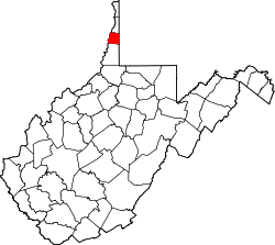
Website: www.ohiocounty.wv.gov Das Ohio County[1] ist ein County im US-amerikanischen Bundesstaat West Virginia. Bei der Volkszählung im Jahr 2010 hatte das County 44.443 Einwohner und eine Bevölkerungsdichte von 161,6 Einwohnern pro Quadratkilometer. Der Verwaltungssitz (County Seat) ist Wheeling.[2]
Inhaltsverzeichnis
Geografie
Das County liegt fast im äußersten Norden von West Virginia im Northern Panhandle, grenzt im Osten an Pennsylvania und im Westen an Ohio, wobei die Grenze durch den Ohio River gebildet wird. Es hat eine Fläche von 282 Quadratkilometern, wovon 7 Quadratkilometer Wasserfläche sind. An das Ohio County grenzen folgende Countys:
Jefferson County
(Ohio)Brooke County Belmont County
(Ohio)
Washington County
(Pennsylvania)Marshall County Geschichte
Das Ohio County wurde am 7. Oktober 1776 aus Teilen des Distrikts West Augusta gebildet. Benannt wurde es nach dem Ohio River.
Der erste Verwaltungssitz war von 1777 bis 1797 in West Liberty, das damals noch den Namen Black's Cabin trug. 1797 wurde die Verwaltung nach Wheeling verlegt, wo sie sich noch heute befindet.
1861 fand in Wheeling die so genannte Wheeling Convention statt, eine Serie von Versammlungen von Vertretern der Countys, die den Abfall Virginias von den USA ablehnten. Dies war die Geburtsstunde des damals neu entstehenden Bundesstaates West Virginia.
Demografische Daten
Historische Einwohnerzahlen Census Einwohner ± in % 1790 5212 — 1800 4740 -9 % 1810 9182 90 % 1820 9182 0 % 1830 15.584 70 % 1840 13.357 -10 % 1850 18.006 30 % 1860 22.422 20 % 1870 28.831 30 % 1880 37.457 30 % 1890 41.557 10 % 1900 48.024 20 % 1910 57.572 20 % 1920 62.892 9 % 1930 72.077 10 % 1940 73.115 1 % 1950 71.672 -2 % 1960 68.437 -5 % 1970 64.197 -6 % 1980 61.389 -4 % 1990 50.871 -20 % 2000 47.427 -7 % 2010 44.443 -6 % Vor 1900[4] 1900–1990[5] 2000[6] 2010[7]  Brücke über den Ohio River in Wheeling
Nach der Volkszählung im Jahr 2010 lebten im Ohio County 44.443 Menschen in 19.797 Haushalten. Die Bevölkerungsdichte betrug 161,6 Einwohner pro Quadratkilometer.
Ethnisch betrachtet setzte sich die Bevölkerung zusammen aus 93,2 Prozent Weißen, 3,7 Prozent Afroamerikanern, 0,1 Prozent amerikanischen Ureinwohnern, 0,8 Prozent Asiaten sowie aus anderen ethnischen Gruppen; 1,9 Prozent stammten von zwei oder mehr Ethnien ab. Unabhängig von der ethnischen Zugehörigkeit waren 0,8 Prozent der Bevölkerung spanischer oder lateinamerikanischer Abstammung.
In den 19.797 Haushalten lebten statistisch je 2,16 Personen.
19,0 Prozent der Bevölkerung waren unter 18 Jahre alt, 62,5 Prozent waren zwischen 18 und 64 und 18,5 Prozent waren 65 Jahre oder älter. 52,4 Prozent der Bevölkerung war weiblich.
Das jährliche Durchschnittseinkommen eines Haushalts lag bei 38.201 USD. Das Pro - Kopf - Einkommen betrug 23.342 USD. 13,9 Prozent der Einwohner lebten unterhalb der Armutsgrenze.[8]
Städte und Gemeinden
- Triadelphia
- West Liberty
- Bethlehem
- Clearview
- Valley Grove
- Betty Zane
- Clinton
- Eden
- Elm Grove
- Greggsville
- Mount Echo
- Mozart1
- Point Mills
- Roneys Point
- Warwood
1 - teilweise im Marshall County
Einzelnachweise
- ↑ Ohio County im Geographic Names Information System des United States Geological Survey Abgerufen am 22. Februar 2011
- ↑ National Association of Counties Abgerufen am 30. Oktober 2011
- ↑ Auszug aus dem National Register of Historic Places - Nr. 70000660 Abgerufen am 30. Oktober 2011
- ↑ U.S. Census Bureau _ Census of Population and Housing Abgerufen am 28. Februar 2011
- ↑ Auszug aus Census.gov Abgerufen am 28. Februar 2011
- ↑ U.S. Census Buero - Volkszählungsdaten 2000 für das Ohio County, WV Abgerufen am 30. Oktober 2011
- ↑ United States Census 2010 Abgerufen am 20. Oktober 2011
- ↑ U.S. Census Buero, State & County QuickFacts - Ohio County Abgerufen am 30. Oktober 2011
Weblinks
-
 Commons: Ohio County, West Virginia – Sammlung von Bildern, Videos und Audiodateien
 - Offizielle Webseite
- U.S. Census Buero, State & County QuickFacts - Ohio County
- Yahoo Bildersuche - Ohio County
- www.city-data.com - Ohio County

Liste der Countys in West Virginia
Barbour | Berkeley | Boone | Braxton | Brooke | Cabell | Calhoun | Clay | Doddridge | Fayatte | Gilmer | Grant | Greenbrier | Hampshire | Hancock | Hardy | Harrison | Jackson | Jefferson | Kanawha | Lewis | Lincoln | Logan | Marion | Marshall | Mason | McDowell | Mercer | Mineral | Mingo | Monongalia | Monroe | Morgan | Nicholas | Ohio | Pendleton | Pleasants | Pocahontas | Preston | Putnam | Raleigh | Randolph | Ritchie | Roane | Summers | Taylor | Tucker | Tyler | Upshur | Wayne | Webster | Wetzel | Wirt | Wood | Wyoming
Wikimedia Foundation.
Schlagen Sie auch in anderen Wörterbüchern nach:
Ohio County, West Virginia — Location in the state of West Virginia … Wikipedia
National Register of Historic Places listings in Ohio County, West Virginia — Location of Ohio County in West Virginia This is a list of the National Register of Historic Places listings in Ohio County, West Virginia. This is intended to be a complete list of the properties and districts on the National Register of… … Wikipedia
List of historic sites in Ohio County, West Virginia — This is a complete list of historic sites in Ohio County, West Virginia. NRHP refers to whether the site is listed on the National Register of Historic Places.Ohio County Historic Sitesee also*Ohio County, West Virginia *List of Registered… … Wikipedia
Historic Politicians from Ohio County, West Virginia — Below is a list of historic and otherwise prominent politicians from Ohio County, West Virginia:*Aquilla B. Caldwell (R) WV Attorney General (1863 1865, 1869 1871) *Granville D. Hall (R) WV Secretary of State (1865 1867) *Chester D. Hubbard (R) U … Wikipedia
List of County Routes in Ohio County, West Virginia — Below is a list of believed county routes for Ohio County, West Virginia*officially named Greggsville, Clinton, Potomac RoadExternal links* [http://www.wvdot.com/countyroadmaps/WVDOH CRM/PDF 04/Ohio,%20sheet%201%20of%201.pdf WV Division of… … Wikipedia
Hardy County (West Virginia) — Verwaltung US Bundesstaat: West Virginia Verwaltungssitz: Moorefield Adresse des Verwaltungssitzes: County Courthouse 204 Washington Street Moorefield, WV 26836 1155 Gründung … Deutsch Wikipedia
Preston County (West Virginia) — Verwaltung US Bundesstaat: West Virginia Verwaltungssitz: Kingwood Adresse des Verwaltungssitzes: County Courthouse 101 West Main Street Kingwood, WV 26537 1121 … Deutsch Wikipedia
Marshall County, West Virginia — Location in the state of West Virginia … Wikipedia
Mineral County, West Virginia — Location in the state of West Virginia … Wikipedia
Mason County, West Virginia — Location in the state of West Virginia … Wikipedia
Ohio County (West Virginia)


18+
© Academic, 2000-2024
- Kontaktieren Sie uns: Unterstützung, Werbung
Wörterbücher Export, schritte mit PHP, Joomla, Drupal, WordPress, MODx.