- Nomuka
-
Nomuka Karte von Nomuka und Umgebung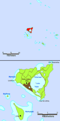
Gewässer Pazifischer Ozean Inselgruppe Haʻapai Geographische Lage 20° 15′ 0″ S, 174° 47′ 20″ W-20.25-174.7888888888945Koordinaten: 20° 15′ 0″ S, 174° 47′ 20″ W 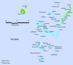
Fläche 7,12 km² Höchste Erhebung Koto Maka
45 mEinwohner 474
67 Einw./km²Hauptort Nomuka Nomuka (auch Numuka, früher Namuka) ist eine 7,12 km² große Insel, die zum Königreich Tonga gehört. Die Insel weist einen seichten, sumpfigen Brackwassersee namens Ano Ava (Wortbedeutung: Sumpfloch) auf, mit drei kleinen Inseln: Puhoʻava, Loto (die größte Insel) und Tefisi. Noch seichter ist die südliche Ausbuchtung des Sees, Mamaha (Wortbedeutung: seicht). Der See erstreckt sich über eine Fläche von rund 2,5 km² und nimmt damit ein gutes Drittel der Inselfläche ein.
Die Insel liegt im Norden der Nomuka Bank, der größten untermeerischen Bank der Tongainseln.[1]
Die Bevölkerung nahm zwischen den Volkszählungen 1996 und 2006 von 550 auf 474 ab.[2] Die Insel liegt im Haʻapai-Archipel. Nomuka ist nur über Boot zu erreichen und wird wöchentlich von Booten aus Nukuʻalofa und Lifuka angefahren.
Einzelnachweise
 Luftaufnahme von Nomuka (verzerrt, da Schrägaufnahme)

Niua-Gruppe: Niuafoʻou | Niuatoputapu | Tafahi
Vavaʻu-Gruppe: Fonualei | Late | Toku | Vavaʻu
Haʻapai-Gruppe: Fatumanongi | Foa | Fotuhaʻa | Haʻano | Hakauata | Kao | Lifuka | Limu | Lofanga | Luahoko | Luangahu | Meama | Niniva | Nomuka | Nukupule | Ofolanga | Tofua | ʻUiha | Uoleva | Uonukuhahake
Tongatapu-Gruppe: ʻAta | ʻEua | Tongatapu
Umstrittenes Gebiet: Minerva-Riffe
Wikimedia Foundation.
Schlagen Sie auch in anderen Wörterbüchern nach:
Nomuka — es una isla del grupo Ha apai, en el reino de Tonga. Está situada a 105 km al norte de Tongatapu. Sus coordenadas son 20°15′S 174°48′O / 20.25, 174.8Coordenadas … Wikipedia Español
Nomuka — is a small island in the southern part of the Haʻapai group of islands in the Kingdom of Tonga. It is part of the Nomuka Group of islands, also called the ʻOtu Muʻomuʻa. Nomuka, is 7 square kilometres in area and contains a large, brackish lake… … Wikipedia
Nomuka-Insel — Karte von Tonga Nomuka ist eine 7 km² große Insel, die zum Königreich Tonga gehört und Schätzungen zu Folge 400 bis 500 ständige Einwohner hat. Die Insel liegt im Haʻapai Archipel. Nomuka ist nur über Boot zu erreichen und wird wöchentlich von… … Deutsch Wikipedia
List of cities in Tonga — The following list gives all islands and cities (villages and hamlets) in Tonga in alphabetical order with many local areas and (poetical) nicknames as well.Layout(An overview of the adopted layout method for each archipelago main group.… … Wikipedia
Hokulea — Hōkūleokinaa [Finney, et al. Voyage of Rediscovery , op. cit., p. xiii, offers pronunciation guidance for the boat s name, The macrons [ kahakō in Hawaiian] over vowels indicate that they are longer than unmarked vowels and are stressed. The… … Wikipedia
Fonuafoou — oder Fonuafo’ou, anderer Name Falcon Island, auch bekannt als „die verschwundene Insel“, ist eine nur zeitweise bestehende Vulkaninsel in der Haʻapai Inselgruppe, die zum Königreich Tonga gehört. Sie liegt 30 km westlich der Nomuka Insel und ist… … Deutsch Wikipedia
Freundschaftsinseln — Puleʻanga Fakatuʻi ʻo Tonga (tongaisch) Kingdom of Tonga (englisch) Königreich Tonga … Deutsch Wikipedia
Kingdom of Tonga — Puleʻanga Fakatuʻi ʻo Tonga (tongaisch) Kingdom of Tonga (englisch) Königreich Tonga … Deutsch Wikipedia
Königreich Tonga — Puleʻanga Fakatuʻi ʻo Tonga (tongaisch) Kingdom of Tonga (englisch) Königreich Tonga … Deutsch Wikipedia
Streitkräfte Tongas — Puleʻanga Fakatuʻi ʻo Tonga (tongaisch) Kingdom of Tonga (englisch) Königreich Tonga … Deutsch Wikipedia
Nomuka


18+
© Academic, 2000-2024
- Kontaktieren Sie uns: Unterstützung, Werbung
Wörterbücher Export, schritte mit PHP, Joomla, Drupal, WordPress, MODx.