- Nieuw-Lekkerland
-
Gemeinde Nieuw-Lekkerland 
Flagge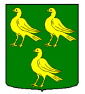
WappenProvinz  Südholland
Bürgermeister Rinus Houtman Sitz der Gemeinde Nieuw-Lekkerland Fläche
– Land
– Wasser12,77 km²
10,40 km²
2,38 km²CBS-Code 0571 Einwohner 9.540 (31. Dez. 2010[1]) Bevölkerungsdichte 747 Einwohner/km² Koordinaten 51° 53′ N, 4° 40′ O51.8833333333334.6666666666667Koordinaten: 51° 53′ N, 4° 40′ O Vorwahl 0184, 078 Postleitzahlen 2957, 2961 Website www.nieuw-lekkerland.nl 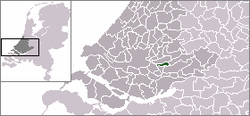
Nieuw-Lekkerland (
 anhören?/i) ist eine Gemeinde am Lek in der niederländischen Provinz Südholland und zählte am 31. Dezember 2010 laut Angabe des CBS 9540 Einwohner. Die Gesamtfläche der Gemeinde beträgt 12,77 km².
 Windmühle Hoge Molen
Inhaltsverzeichnis
Ortsteile
- Kinderdijk
- Nieuw-Lekkerland (Dorp und Middelweg). Hier befindet sich das Rathaus.
Sitzverteilung im Gemeinderat
‣ PvdA: 4 Sitze ‣ SGP: 3 Sitze ‣ CU: 3 Sitze ‣ VVD: 2 Sitze ‣ CDA: 1 Sitz Weblinks
 Commons: Nieuw-Lekkerland – Sammlung von Bildern, Videos und Audiodateien
- Website der Gemeinde
- Website der Historischen Vereinigung West-Alblasserwaard
- Internetgemeindeführer Nieuw-Lekkerland
- Website von Middelweg
Einzelnachweise
 Gemeinden der Provinz Südholland
Alblasserdam | Albrandswaard | Alphen aan den Rijn | Barendrecht | Bergambacht | Bernisse | Binnenmaas | Bodegraven-Reeuwijk | Boskoop | Brielle | Capelle aan den IJssel | Cromstrijen | Delft | Den Haag | Dirksland | Dordrecht | Giessenlanden | Goedereede | Gorinchem | Gouda | Graafstroom | Hardinxveld-Giessendam | Hellevoetsluis | Hendrik-Ido-Ambacht | Hillegom | Kaag en Braassem | Katwijk | Korendijk | Krimpen aan den IJssel | Lansingerland | Leerdam | Leiden | Leiderdorp | Leidschendam-Voorburg | Liesveld | Lisse | Maassluis | Middelharnis | Midden-Delfland | Nederlek | Nieuw-Lekkerland | Nieuwkoop | Noordwijk | Noordwijkerhout | Oegstgeest | Oostflakkee | Oud-Beijerland | Ouderkerk | Papendrecht | Pijnacker-Nootdorp | Ridderkerk | Rijnwoude | Rijswijk | Rotterdam | Schiedam | Schoonhoven | Sliedrecht | Spijkenisse | Strijen | Teylingen | Vlaardingen | Vlist | Voorschoten | Waddinxveen | Wassenaar | Westland | Westvoorne | Zederik | Zoetermeer | Zoeterwoude | Zuidplas | Zwijndrecht
Wikimedia Foundation.
Schlagen Sie auch in anderen Wörterbüchern nach:
Nieuw-Lekkerland — Héraldique … Wikipédia en Français
Nieuw-lekkerland — Nieuw Lekkerland … Wikipédia en Français
Nieuw-Lekkerland — Municipality Flag … Wikipedia
Nieuw-Lekkerland — Nieuw Lẹkkerland [ niːu̯ ], Gemeinde in der Provinz Südholland, Niederlande, am linken Ufer des Lek, 9 100 Einwohner; Metallindustrie, Betonfertigteilherstellung. Zu Nieuw Lekkerland gehört Kinderdijk … Universal-Lexikon
Nieuw-Lekkerland — Original name in latin Nieuw Lekkerland Name in other language N iv Lekkerland, Ньив Леккерланд State code NL Continent/City Europe/Amsterdam longitude 51.88915 latitude 4.68653 altitude 0 Population 9535 Date 2013 06 09 … Cities with a population over 1000 database
Kinderdijk — Réseau des moulins de Kinderdijk Elshout * Patri … Wikipédia en Français
Réseau des moulins de Kinderdijk-Elshout — Kinderdijk Moulins à Kinderdijk Kinderdijk est un village des Pays Bas, situé à cheval sur le territoire des communes de Nieuw Lekkerland et d Alblasserdam, à environ 15 km à l est de Rotterdam. Le village se trouve dans un polder au… … Wikipédia en Français
Ньив-Леккерланд — Город Ньив Леккерланд нидерл. Nieuw Lekkerland Флаг Герб … Википедия
Kinderdijk — Coordinates: 51°53′N 4°38′E / 51.883°N 4.633°E / 51.883; 4.633 … Wikipedia
List of places in the Netherlands — This is an alphabetical list of places (cities, towns, villages) in the Netherlands. Lists per province can be found at:* List of towns in Groningen * List of towns in Friesland * List of towns in Drente * List of towns in Overijssel * List of… … Wikipedia
Nieuw-Lekkerland


18+
© Academic, 2000-2024
- Kontaktieren Sie uns: Unterstützung, Werbung
Wörterbücher Export, schritte mit PHP, Joomla, Drupal, WordPress, MODx.