- Ngarchelong
-
Ngarchelong 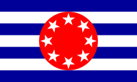
Geographie Staat: Palau Gewässer: Pazifischer Ozean Inseln: Babelthuap Geographische Lage: 8° N, 135° O7.7134.61666666667Koordinaten: 8° N, 135° O Basisdaten Fläche: 10 km² Einwohner: 488 Bevölkerungsdichte: 49 Einw./km² Hauptstadt: Mengellang Lagekarte 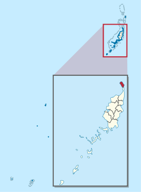
Ngarchelong ist ein administrativer Staat (d.h. ein Verwaltungsgebiet) der westpazifischen Inselrepublik Palau. Er liegt im äußersten Norden der Hauptinsel Babelthuap. Hauptort ist Mengellang.
Das 10 km² große, aber nur spärlich besiedelte Verwaltungsgebiet mit den acht kleinen Dörfern (hamlets) Ollei, Mengellang, Ngebei, Iebukel, Ngerbau, Ngriil, Ngeiungel und Ngermetong grenzt südlich an den Bezirk Ngaraard. Ngarchelong hat laut Volkszählung von 2005 lediglich 488 Einwohner[1].
Weblinks
- CUSTOMARY MARINE TENURE AND TRADITIONAL ECOLOGICAL KNOWLEDGE IN PALAU (Kayangel and Ngarchelong (engl.). (PDF-Datei; 6006 kB)
Einzelnachweise
Schlagen Sie auch in anderen Wörterbüchern nach:
Ngarchelong — es un estado de Palau. Localizado en el extremo norte de la isla de Babeldaop. Es un sitio histórico y arqueológico muy importante del área. Es sitio de antiguos monolitos de piedra de origen misterioso. La religión tradicional palauana considera … Enciclopedia Universal
Ngarchelong — Flag of Ngarchelong Previous flag of Ng … Wikipedia
Ngarchelong — 7°42′N 134°37′E / 7.7, 134.617 Ngarchelong … Wikipédia en Français
Ngarchelong — Coordenadas: 7°42′N 134°37′E / 7.7, 134.617 … Wikipedia Español
Ngarchelong — Admin ASC 1 Code Orig. name Ngarchelong Country and Admin Code PW.09 PW … World countries Adminstrative division ASC I-II
Ngerchelong — Ngarchelong Ngarchelong Drapeau Administration Pays … Wikipédia en Français
PW-218 — Flagge von Ngarchelong Administrative Gliederung von Palau. Ngarchelong ist ein administrativer Staat (d.h. ein Verwaltungsgebiet) der westpazifischen … Deutsch Wikipedia
PW-214 — Administrative Gliederung von Palau. Ngaraard ist ein administrativer Staat (d.h. ein Verwaltungsgebiet) der westpazifischen Inselrepublik Palau. Er liegt im Norden der Hauptinsel Babelthuap. Hauptort ist Ulimang. Das etwa 36 km² große… … Deutsch Wikipedia
Flagge Palaus — Vexillologisches Symbol: ? … Deutsch Wikipedia
Ngaraard — is the eighth state of the Republic of Palau, and was originally named Kerradel. Ngaraard is located on the northern tip of Babeldaob directly adjacent to Ngarchelong state. There are five hamlets in Ngaraard, including Choll, Elab, Ngebuked,… … Wikipedia
Ngarchelong


18+
© Academic, 2000-2024
- Kontaktieren Sie uns: Unterstützung, Werbung
Wörterbücher Export, schritte mit PHP, Joomla, Drupal, WordPress, MODx.